A short list of chase terms and acronyms
For a comprehensive listing of terms: go to NWS Norman, OK , Skywarn, or NWS SRH Weather School.
ACCUS - Altocumulous Castelanus
Atomic - Usually used in reference to CAPE above 4000 J/kg
Bear's Cage - The area under the mesocyclone in a supercell where extreme hail is possible
Bust - A storm chase that ends without seeing anything
Bow Echo - An echo on radar shaped like an archer's bow. Wind damage is possible ahead of the bow.
Cap - Warm air aloft which prevents thunderstorm initiation
CAPE - Convective Available Potential Energy
Cb/CB - Cumulonimbus cloud as well as the occasional reference to radio.
CG - Cloud to ground lightning strike
CIN - Convective Inhibition; amount of "negative bouyancy" before reaching the level of free convection (LFC)
Chase Target - A pre-determined area a chaser heads toward in search of the storm (e.g. 50 miles within a certain town)
Cold Front - Synoptic scale boundary of intruding cold air
"Come to Papa!" - Frequently used statement by University of Nebraska students to quantify potential for extreme weather events
Convection - Rising parcel of bouyant air; another term for thunderstorms
Core - Area of most intense rain and hail within a storm
Core Punching - The act of driving through the core
Corkscrew - Term used to describe the shape of a rotating updraft
CWA - County Warning Area
Cu - Short for cumulus; Atomic notation for copper
Dewpoint - Td; Temperature at which dew would form with current moisture content
Dryline - Intusion of dry air at the surface accompanied by a windshift
EL - Equilibrium level. Level where a rising parcel is no longer more bouyant than its surroundings
Flying Saucer - Term used to describe a photogenic mesocyclone; a UFO; the result of throwing a dish after a busted chase
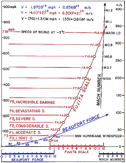
Fujita Scale (F-scale) - The primary tornado damage scale used in the United States designed by Ted Fujita
H85, H70, H50, H25, etc. - Atmospheric pressure level acronyms
High Risk - Highest threat outlook issued by SPC (see Come to Papa!)
Hook Echo - Appearance on radar of a hook shaped appendage on a storm. The feature may be indicatitive of a potential tornado.
Inflow - Air flowing into a storm or tornado
Lifted Index (LI) - The resulting temperature difference between a mixed parcel of air in the lowest 100-mb and lifted to 500-mb and the environmental temperature at 500-mb. The more negative, the greater instability and potential for severe weather.
LFC - Level of free convection. The height at which a parcel will rise freely to the level of equilibrium (EL).
LLJ - Low Level Jet, stream of air found near 850-mb that is usually strongest in the morning hours
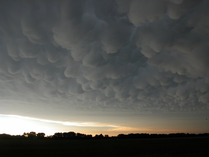
Mammatus - Pouch shaped clouds indicating sinking air (image)
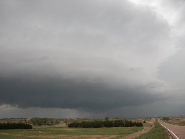
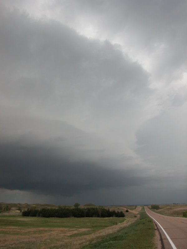
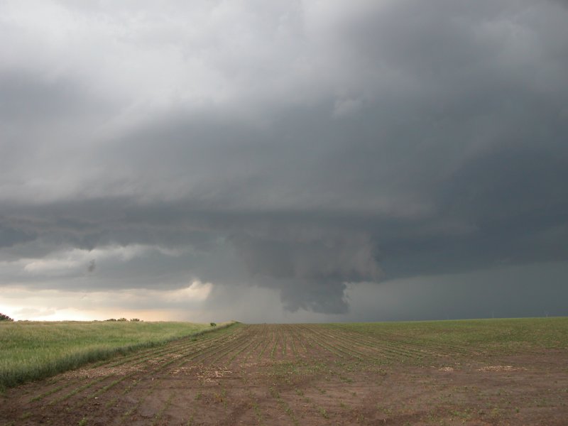
Meso(cyclone) - Rotating portion of a thunderstorm (image)
Mesoscale Discsussion - MD; statements/discussion issued by SPC usually pertaining to severe potential often before an actual watch is issued
Model - A computer generated forecast (Eta, GFS, MM5, etc.); or what you see on a Victoria's Secret ad.
Moderate Risk - An outlook issued by SPC, the potential for significant servere weather
Mothership - see flying saucer (image)
Mountain Dew - A beverage produced by Pepsi Co. and something storm chaser Dr. Ken Dewey at the University of Nebraska doesn't leave home without.
Multiple Vortex - Usually referring to multiple suction vorticies within a tornado.
Naders - Slang for tornadoes (also; nadoes, tors, twisters, cyclones)
Nowcast - A forecast for immediate changes in weather conditions
NWS - National Weather Service
Outflow - Air flowing out of a thunderstorm
Outflow Boundary - A boundary created as a result of outflow from a thunderstorm
Outlook - Referring to SPC convective outlooks
Rain Wrapped - A tornado obscurred by rain (and sometimes hail) wrapping around it
Reflectivity - Intensity of Doppler radar echoes
RFD - Rear Flank Downdraft
Rope - A thin, sometimes spiraling tornado
Rotation - What storm chasers and spotters look for in a storm or wall cloud
SDS - Supercell Deprivation Syndrome.
Shear - The change in wind speed and direction with height
Shotgun - The name of the passenger seat in a (chase) vehicle. The term was initially used by truckers who had a companion in the passenger seat armed with a shotgun to defend the load from thugs or highway pirates (refer to the movie The Fast and the Furious).
Slight Risk - An outlook issued by SPC; Severe storms are possible but conditions do not warrent immediate higher risk
SPC - Storm Prediction Center
Supercell - A longlived thunderstorm with a rotating updraft
Stove Pipe - Another description of tornado shape
Tornado - Need I say more? ... A funnel extending from the ground to the cloud base.
Tornado Alley - The area of the United States most frequented by tornadoes, interpretation will vary from person to person.
Tower - A tall convective cloud
Tube - see stove pipe
Updraft - The area of rising vertical motion within a convective cloud
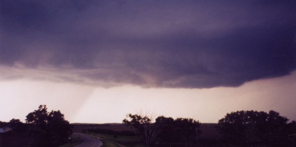
Wall Cloud - A lowering in the cloud base which can take many shapes, often the precursor of a tornado (image)
Warm Front - A synoptic scale boundary of warm air intruding on more dense cold air
Warm Sector - The area between the warm front and dryline or cold front
Warning - A severe weather event is occurring or imminent (e.g. Tornado Warning).
Watch - Conditions are favorable for severe weather and should be monitored for rapid change.
"We're all gonna die!" - Statement made by St. Cloud State University synoptic meteorology professor Bob Weisman when the computer models forecast a significant storm system or when the MPX NWS forecast office hypes a storm forecast.
Wedge - A tornado as wide as it is tall (up to the cloud base). Term often used in chaser "caught the big fish (tornado)" stories.